Picking the right Gnss Ins System can honestly feel pretty overwhelming at times. With so many options out there, it's no wonder people get a bit lost. I mean, Dr. John Smith, a top expert in navigation tech, once said, “Choosing the right GNSS INS system is all about understanding your unique needs and the environment you'll be working in.” That really hits the point home — you gotta think tailored solutions are key.
Getting a good grasp on what a GNSS INS system actually offers is super important. Things like high accuracy, how well it integrates with other tech, and its ability to crunch data in real time are all essentials for good performance. It’s not just about reading specs and charts; sometimes, something might look perfect on paper but just won’t cut it in real life. That’s where expert advice can really help spot those potential issues early on.
Your choice isn’t just a technical matter — it impacts your project timelines, your budget, and your overall success. It’s a smart move to hear what others in the industry have learned from their experiences — might save you from a few headaches down the line. Every GNSS INS system has its pros and cons, after all. By really matching the system to what you need, you’re much more likely to improve your workflow and nail your project goals.
Understanding GNSS INS Systems and Their Applications
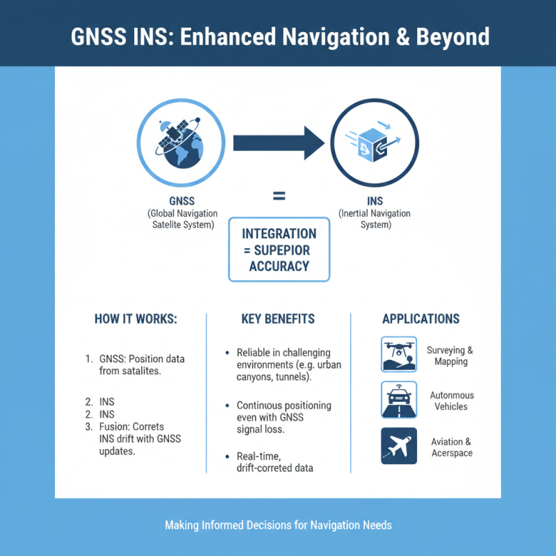
GNSS INS systems integrate global navigation satellite systems (GNSS) with inertial navigation systems (INS) to enhance positioning accuracy. These systems are widely used in sectors like surveying, autonomous vehicles, and aviation. Understanding the applications of Gnss And Ins helps users make informed decisions about their specific needs.
In surveying, GNSS INS systems provide precise geospatial data essential for topographical mapping. The combination of satellite data and inertial measurements ensures accuracy even in challenging environments. Autonomous vehicles benefit from this integration, navigating complex terrains where standalone GNSS might struggle. The limitations of GNSS can affect reliability in urban areas or under heavy canopies. Thus, the inertial component compensates by offering continuous tracking.
Another application is in aviation, where pilot navigation significantly relies on GNSS INS systems. These systems enhance safety and reduce pilot workload during flight. However, pilots must still be aware of potential system limitations. Incorrect readings can occur due to signal obstruction. This awareness promotes a deeper understanding of the technology's strengths and weaknesses, ultimately leading to better operational decisions.
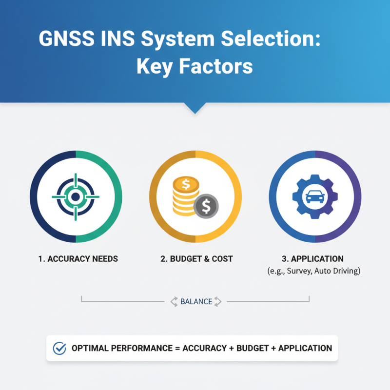
Key Factors to Consider When Selecting a GNSS INS System
Choosing the right GNSS INS system involves multiple considerations. Start by evaluating the accuracy required for your specific applications. Whether it's surveying, mapping, or autonomous driving, the precision can greatly influence performance. High-accuracy systems are available, but they tend to be more costly. Finding a balance between accuracy and budget is crucial.
Next, consider the environmental conditions where the system will operate. Factors such as terrain, obstacles, and weather can impact performance. For instance, urban canyons can create signal obstructions. Systems with better antenna designs and signal processing can mitigate these issues. Additionally, think about the integration with other sensors. A seamless connection to cameras or LiDAR can enhance data collection.
User experience should not be underestimated. The system should offer intuitive interfaces and reliable support. However, not all manufacturers provide the same level of documentation or assistance. It's worth researching user feedback and expert opinions. Remember, choosing a system isn't just about immediate needs. Consider future upgrades and capabilities as technology evolves. Embrace the complexity of the decision-making process and reflect on your long-term goals.
Evaluating Accuracy and Precision for GNSS INS Systems
When choosing a GNSS INS system, accuracy and precision are crucial. Reports indicate that accuracy varies significantly among available systems, often rated between 1 cm to 10 cm for high-end models. This is vital for sectors like surveying, where centimeter-level precision can affect project outcomes. In contrast, many commercial-grade systems might only achieve a meter-level accuracy, which isn't suitable for all applications.
Evaluating the Gnss Vs Ins capabilities is essential in this decision process. GNSS alone may struggle in environments with poor satellite visibility, leading to drift issues. Integrating inertial navigation systems can mitigate these challenges. Some studies suggest that combining GNSS with INS can improve positioning accuracy by up to 50%, particularly in urban canyons or dense forests. However, integrating these technologies can raise costs and complexity, which organizations need to weigh carefully.
It’s also important to consider the environment in which the system will operate. Factors like interference and multipath signals can affect performance. Relying solely on GNSS signals can lead to inconsistencies, prompting a need for reliable INS integration. Reflecting on these aspects ensures a more precise alignment with your specific operational requirements.
How to Choose the Best GNSS INS System for Your Needs? - Evaluating Accuracy and Precision for GNSS INS Systems
| Feature |
Description |
Accuracy (m) |
Precision (m) |
Price Range (USD) |
| Basic GNSS INS |
Entry-level systems suitable for basic navigation tasks. |
2.0 |
0.5 |
$1,000 - $2,500 |
| Survey-grade GNSS INS |
High-accuracy systems for surveying and mapping applications. |
0.01 |
0.01 |
$5,000 - $15,000 |
| Real-time Kinematic (RTK) |
Provides real-time corrections for high precision. |
0.01 |
0.005 |
$10,000 - $25,000 |
| High-performance GNSS INS |
Top-tier systems for advanced navigation in challenging environments. |
0.005 |
0.001 |
$20,000 - $50,000+ |
Exploring Different Types of GNSS INS Systems Available
When selecting a GNSS INS system, understanding the various types available is crucial. Different systems offer unique capabilities that cater to specific applications. For instance, tactical-grade systems are highly precise and designed for military or advanced surveying tasks. Meanwhile, consumer-grade systems are more accessible and suitable for general navigation needs. According to recent industry reports, high-performance GNSS INS systems have improved accuracy to within a few centimeters, elevating operational efficiency in various sectors.
Another aspect to consider is the integration of sensor data. Some GNSS INS systems combine data from IMUs, which can enhance positioning accuracy. This integration is particularly beneficial in environments where GNSS signals may be weak or obstructed. Research indicates that systems using multi-frequency GNSS signals offer a more robust performance, reducing errors caused by atmospheric disturbances. Yet, not all users need this level of precision; some might find it excessive and costly.
Lastly, the user interface and software support are often overlooked factors. A complex interface can hinder usability, especially for non-experts. Many reports highlight that intuitive software can significantly improve fieldwork efficiency. Reflecting on experiences shared by professionals, the right choice often depends on the balance between required accuracy and ease of use. Each application is unique, and finding the right system frequently involves trial and error.
Assessing Environmental Conditions for GNSS INS Use
When evaluating GNSS INS systems, it's crucial to consider environmental conditions. Factors such as terrain, weather, and urban interference can significantly affect GNSS accuracy. For instance, dense forests or urban canyons might block satellite signals. This obstruction leads to diminished performance. In contrast, open fields provide a clearer line to the sky, enhancing signal reception.
Weather also plays a vital role. Heavy rain or snow can degrade signals. Dust storms or fog may introduce errors. It's essential to assess average weather patterns in your operational area. These conditions can impact the reliability of your GNSS INS system. Testing your equipment under varying environmental conditions can reveal potential weaknesses.
Lastly, consider the specific application of the GNSS INS system. Mapping? Surveying? These use cases demand different levels of accuracy. The operational environment and intended use should guide your choice. Understanding these factors provides better insight into your overall requirements. This reflection can help ensure you select the most suitable system for your needs.
Budget Considerations and Cost-Effectiveness in GNSS INS Systems
When considering GNSS INS systems, budget plays a crucial role. High-quality systems often come with a steep price tag. However, balancing cost and performance is essential. An understanding of your specific needs can help eliminate unnecessary features that inflate costs.
It's vital to identify the key features you need. Look for solutions that provide essential functionality, avoiding extravagant options that may not be useful. Assess the amount of accuracy and reliability required for your application. This consideration may reveal that some Gnss Ins Solutions could exceed your actual needs.
Tips:
Evaluate your project's scope and budget before deciding.
Explore options for used or refurbished systems that meet your needs without overspending.
Always read reviews and consult professionals who have experience with various GNSS INS solutions.
User Needs and Customization Options for GNSS INS Solutions
When selecting a GNSS INS system, understanding user needs is crucial. Different applications, such as surveying, agriculture, or construction, require tailored solutions. Users might prioritize accuracy, response time, or adaptability to various terrains. Customization options can significantly enhance system performance, catering to specific requirements. An INSP that offers flexibility in features can be more valuable than a one-size-fits-all solution.
Consider the Software Post Processo Gnss Ins as a vital component in system design. This software often dictates how collected data is analyzed and used. Some users might find standard software inadequate for complex tasks. Preferences can lean toward systems that allow for adjustments and specific configurations. It’s essential to explore what functionalities are available and how they align with personal or project needs.
Many who choose a GNSS INS system find themselves needing further adjustments down the line. They may not fully grasp the implications of their choices at first. Users might overlook certain capabilities that could enhance the system’s usability. Reflecting on these experiences can guide future purchases and lead to a more satisfying solution in the end.
Harnessing High Precision Integrated INS970 for Navigation in GPS-denied Environments: A Comprehensive Guide
In GPS-denied environments, such as those encountered during offshore oil and gas operations, accurate navigation becomes a pivotal challenge. The integration of high-precision navigation systems like the INS970 can significantly enhance operational efficiency and safety. By employing a sophisticated combination of fiber optic gyroscopes and MEMS accelerometers, the INS970 provides reliable positioning even in the most demanding conditions. This technology ensures that operators can navigate and maintain infrastructure in remote and hazardous areas with confidence.
The INS970 solution excels in delivering real-time data, which encompasses crucial parameters such as heading, speed, attitude, and angular rates. This capability is essential for subsea navigation and asset inspections, allowing crews to make informed decisions and optimize their operations. Furthermore, its compact design and low power consumption make it an ideal choice for a wide range of applications, including aerospace, unmanned aerial vehicles (UAVs), and marine engineering surveying. With the ability to support external sensors, the system enhances navigational capabilities, ensuring that even in the absence of satellite signals, safety and reliability are never compromised.
FAQS
: Start by assessing the accuracy needed for your specific applications. Accuracy can greatly affect performance.
High-accuracy systems can be expensive. It's important to find a balance that suits your budget.
Terrain and weather can impact performance. Obstacles like buildings and trees can block signals.
Heavy rain, snow, dust storms, and fog can degrade GNSS signals and introduce errors.
A good system connects well with cameras and LiDAR, enhancing data collection capabilities.
Intuitive interfaces and reliable support are essential. Research user feedback before deciding.
No, consider future upgrades and technological advancements that may impact your choice.
Test under various environmental conditions to identify potential weaknesses and improve reliability.
Different applications like mapping and surveying require varying levels of accuracy. Choose based on intended use.
Understanding your long-term needs helps ensure the selected system will remain suitable over time.
Conclusion
Choosing the right GNSS INS system involves a comprehensive understanding of its functionalities and various applications. It is essential to consider key factors such as accuracy, precision, and environmental conditions to ensure the selected system meets specific operational needs. Different GNSS INS systems offer unique features tailored for various use cases, and evaluating these differences can significantly impact performance.
Additionally, budget considerations play a crucial role in the decision-making process, as cost-effectiveness should align with user requirements. Customization options further allow for a tailored approach, ensuring that the GNSS INS system effectively addresses individual preferences and operational demands. Ultimately, careful evaluation of these elements will lead to the optimal choice of a GNSS INS system for any given scenario.
 TBSD60
 BSD120
 BSD98
BSD98 BSD70
BSD70 BSD60
BSD60 BSD50
BSD50 BSD217
 INS1700
 INS970
 INS570
 INS170
 SLA-4B1L1-65
 SLA-8B1L1-110
 SLA-4B1L1-130
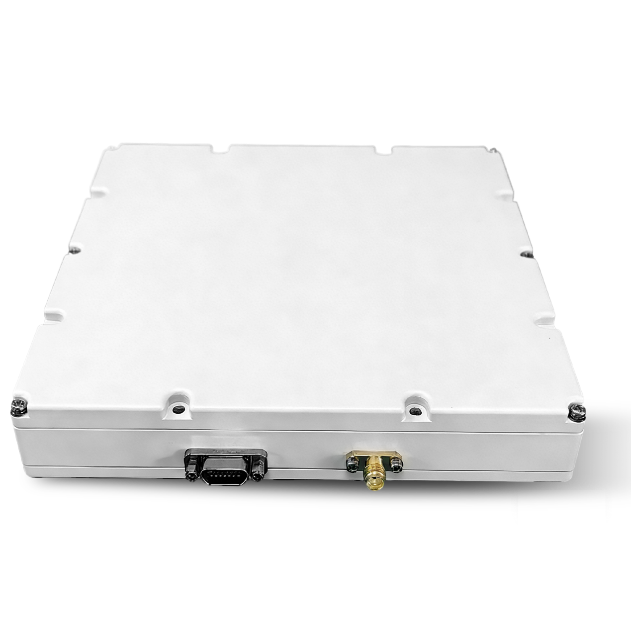 SLA-16B1L1-160
 SLA-8B1L1-165
 101 Vessel-mounted Positioning
 102 Acoustic Communication
 103 Tracking and Locating
 104 Diver Navigation System
 105 Intrusion Detection Sonar
 106 Delivery Locator Beacon
 SLLR3000
 SLLR905
 SLLD25
 108IMU
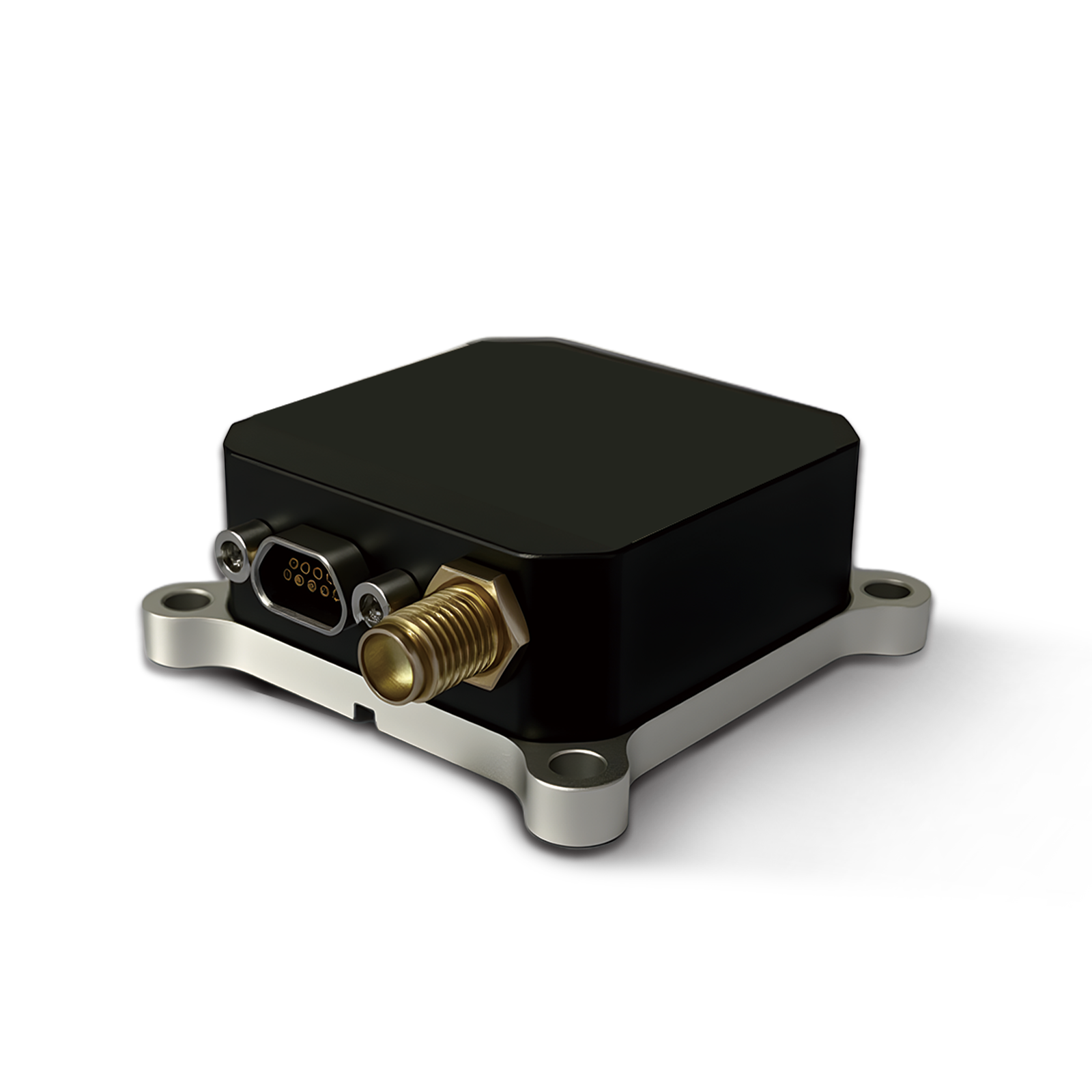 150M
150M 500MH
500MH 160M
160M 170M
170M SLFC-70
 SLAF280
 MR360
MR360